
Description:
 Kaghan valley is named after the town of
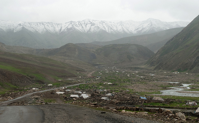
  Lofty peaks crown the mountains ranges on either side like turrets, ranging in height from 12,000 to 17,000 ft and more, with the eastern range higher than the western. The bed of valley slopes up from 3,000 ft at Balakot, which, as it were, the gateway of the valley, to 12,000 ft at Gittidas beyond which the valley crosses at Babusar Pass 14,000 ft.
 The local people are friendly and simple. Popular languages are Hindko and Gojri, while
The road from Balakot ascends along the


 You'll find the Himalayan peaks hidden with clouds or snow, somewhere you'll find the beautiful fairy tale lakes, which will attract you toward them, and you might decide not to leave this at any cost. Where Kaghan is full of scenic beauty there it is full of thrill and excitement for the mountaineers and treks. That's why it is called virtual paradise, unbelievably in pristine state and still unspoiled by the human.


 Fishing is the chief sport in Kaghan. Brown Trout and Mahasher are stocked in pure silvery waters in the upper parts of the valley. The Kunhar river trout is considered to be the best throughout the sub-continent. Fishing licenses are issued by the 'Fisheries Department at Naran' or by the 'Trout Hatchery' at Shinu. Apart from this there are some other private trout fish farms at Kawai (also spelled as Kiwai) and Kahania.
 One of the most interesting features of the Kaghan area is the Gujar (herder) families you'll see along the way bringing their animals up to the summer pastures. On the way up to Naran, you will see so many cattles walking along on the road, a totally new scene to look at such a view, beautiful and happy. You will find them camped along the road in their tents or moving up the valley with their goats, sheep and pack animals around the start of summer and on their way back to lower altitudes around the beginning of winter. this place is worth to see.
Climate:

 In summer it is possible to continue to
  The best time to visit Kaghan is in summer months (May to September). From the mid - July up to the end of September, the road beyond Naran, snow-bound throughout the winter, is open right up to Babusar Pass. Movement may be restricted during the monsoon season due to heavy rains and landslides.
Places to See:
Balakot:


 This beautiful small town is situated on either banks of Kunhar river at the foot of the mountains that goes thousands of feet above. The toy huts, which are amazingly perched on their slopes. On other side is the

Kewai:

 Shogran:
The main place here to visit is Shogran, which is 5 miles jeep able trek from Kiwai, and further 5 miles you'll go up another 3000 feet. Now you are 7000 feet above the sea level and rightly so because Shogran means "Forest in the sky". You'll be able to view the some of the lofty peaks from here, which are " Moosa Ka Musalla " and " Makra "having height of 14000 feet, and Malika-e-Parbat (Queen of the Mountains) (17000 feet).

Mini Zoo, Pine Park


Siri and Paya:


 Hike is also possible from Shogran but its gonna take you two n half hours. Keep in mind its very tough hike. You can also camp at Paya if you are in group with having all necessary equipment n stuff. Once you reach Paya the discomfort of the journey is forgotten.


 You will see there some huts of herdmen with their herds. You must visit this place to witness the natural beauty ok Kaghan valley. Best time to visit is early in the morning, as during peak tourist season, the place will become jam packed with visitors.
Makra Peak:
 Makra is worth seen mountain between Kaghan and Azad kashmir.Its not such huge like K2 or Nanga parbat(12,744 Ft)but its between one of famous mountain of Kaghan valley.It has the shape like Spider and has 8 different ways which leads you different tracks.Thats why it called Makra and no doubt its the biggest Spider on earth.
Manna Meadows:


Paras:


Sharan Meadows:


Shinu:
Just beyond Paras is known for its trout hatchery of the Fisheries Department. It is from this hatchery that brown trout and rainbow trout are stocked into the upper Kunhar river and the lakes Saiful Muluk, Lulusar and Dodiputsar.
Jareed:

Mahanderi:
 Even farther is the village of Mahanderi where a stream from Munawar valley flows into the Kunar. Walking treks to Munawar Gali, Biyarhi, and Kach Gali originate from Mahandheri.
Manur Gali:
 The 4100m high above sea level, Manur Gali connects Lake Saiful Malook to Muhandri. This rout is an extravaganza of nature painted with crystal clear streams, flowering meadows, cascading glaciers and dense forest.
 Beautiful remote Manoor Valley is accessible via a jeep road from Mahundari. There is a forest department rest house in the Manoor Valley called Manoor Bangla. It is a beautiful rest house in absolute wilderness. It can be booked in advanced from Forest department office at Mansehra to remain on the safe side. However you can always pitch your camp there or get a room (depending upon the availability) from the chacha (bungalow keeper).
Khanian:

Danna Meadows:
 A ten kilometer jeep track winds up the hillside to picturesque Dana Meadows which are located at an altitude of 10,000 feet with a view of a number of snow covered peaks over 15,000 feet. It takes an hour to reach here by jeep (as this trek was also xxxshhbh
 destroyed by the earth quake so dana is no more Jeepable), and about three hours on foot. On foot u cant make it back in one day as its a steep climb.So a over night stay is must at Danna.
 More over the place is so much beautiful. Take some food stuff, warm clothes, sleeping bags along. If you want to see the real stunning beauty of Danna visit it between 15 June to 15 August. The place is absolutely safe from bandits even in a Jungle. For camping its also ideal in summer but in current days fear of leopard/bear can not be ignored.
Kamal Ban:
Another jeep track to the south from Khanian climbs up the ridge to the Kamal Ban Forest. The forest rest house at Kamal Ban is at an altitude of 6500 feet and was built in 1924, being one of the oldest in the area. It also offers a beautiful view of surrounding mountains. There is a jeep-able trek leading to Manna Meadows on right and Kamal Ban on left. Further trekkers can also enjoy the Kamal Ban to Jarid path.

One way or another, Kamal Ban is a thick forest with some wild animals like Tiger & Bears. There were few accidents in the area this season as man come across the path of these wild animals.
Musa ka Musalla:
 Musa ka Musalla peak stands at an altitude of 4050 meters at the junction of Siran and Kaghan valleys. The name translates to Moses’ Mat which has different stories associated with it. While some believe it to be named after a local shepherd with the name of Musa who used to pray at the peak here, some even attribute it to the prophet Moses. There is a small flat structure made up of different stones and marked with colorful flags of type one finds in all the shrines of this region. On a clear day, the summit offers exciting panoramic views of the entire area and surroundings.
 There are many possible options to reach Musa ka Musalla top. It can be accessed from both Kaghan and Siran valleys. Trekkers have been using four basic routes to access Musa ka Musalla which are described below.
1. From Mandakucha/Jacha village:

2. From Naddi Bangla:

3. From Kund Bangla / Shaheed Pani:
 There are forest rest houses on both the places and they can be reached via Masehra/Shinkiari. This is the longest re oute in terms of walking distance but is less hectic in terms of steepness. Jeeps take 3-4 hours from Shinkiari to reach Kund where one can stay at forest rest house for the night. From Kund, a 3-4 hours trek can take one to Shaheedpani where there is another rest house. From Shaheehpani, one can reach Shaddal Gali/Thandi Gali in 4-5 hours on a relatively flat terrain where the trail coming from Naddi Bangla joins in. From the gali, summit of Musalla can be reached in 2-3 hours. In all, the whole trek from Kund Bagla to Musalla peak takes 10-12 hours.
4. From Sharan:
Sharan is a beautiful forested place that can be reached from Kaghan (Paras) on a jeep. There is a rest house and youth hostel available at Sharan. This is the most difficult option in terms of steepness and is not generally recommended for reaching the top. This option can be considered however for coming back which is all descend and takes around 7-8 hours.

Best time to do this trek is from mid June to mid September. Some groups also attempt it in winters in harsh conditions as a winter survival expedition. As with the other treks of the region, porter rates are not already defined and would have to be negotiated. Porters would charge on per day basis and it could be anything between Rs. 500 and 1000. A horse or mule can be hired on something between Rs. 1000 – 1400 per day (Rates as per summer of 2010).
Kaghan:

Malkandi Forest:
 8 miles on the western slopes of Kaghan is Kamalban, a heavily populated forest of black bears and leopards, which do incalculable harm to the crops and young trees. Killing a bear is a big game and you'll get reward for shooting down a bear from forest officer as well as from the peasants. Besides these you'll be able to find Muskdeer, thar and goral, Chikore and Himalayan pheasants all over the valley. And if you'll go a little higher you'll be able to find red bear, snow leopard and ibex and occasionally a snow partridge or Ram Chikore or Murgh-I-Zarrin.
Shingri:

 Mukhlaian:
Mukhlaian is a small charming village on the way to Shingri. It is about 8 km from Kaghan town and can be reached by jeep after a danger drive.
Naran:


Naran is awash with hotels, restaurants, and shops, all neatly arranged on both sides of the Kaghan road. The roar from the gushing waters of Kunar River creates a pleasant atmosphere.

Naran is the place of out-door pleasure. Here you'll depart from the river Kunhar and on both sides of road there are vast fields. Don't look here and there the melody you are hearing is provided by the river Kunhar who is with you on same level. If you like climbing this is a place for you because there are mountains all around you. You can explore the scenic and pictorials landscape and valleys by climbing up hiking. If you like fishing get your fishing license we have trout and mahasheer for you fishing here for tourist is must.
 For beginners or people who just want to walk a short distance, a gentle walk starting from PTDC hotel, over a bridge takes you to the other side of River Kunhar. Veer left and follow the trail. A small track follows Kunhar for a short distance till you reach another make shift bridge. You cross it and enter the main market place. This walk takes about 1-2 hours. Depending how fast you go. Also lots of flora and fauna on this trail.
The river itself is still unexplored. There is a potential for white water rafting, and other water sports associated with fast flowing rivers.


Naran is the best base for treks and walks in the valley. There are options for accommodation and restaurants. Naran is best reached by jeep from Balakot some 200 km north of RawalPindi / Islamabad.
Damdama:

There is a village named damdama at 4-5 km after crossing naran and going towards batakundi. Damdama top is really fantastic place Naran is visible from the top.
 Lalazar is the second visit that most tourist do when visiting Naran (Saiful Muluk is the first). Situated on the other end of Lake Saiful Muluk, over the mountain, at a distance of 21 km from Naran via Battakundi, located at 3,200m, it is a 1/2-day jeep excursion with several twists and turn.
 Lalazar is accessible by a muddy narrow jeep track. A jeep track from battakundi climbs up the plateau. The road to Lalazar is a typical Pakistani Mountain road, with hills on one side and a deep "Khud" (valley) on the other side.The only difference was that the "Khud" is the Kunhar River.
 This beautiful meadow is awash with colourful alpine flowers in spring and summer, and set amongst the cool pine forests. It is the most beautiful hill station in Kaghan Valley with its meadows and pine thickets. A large green plateau gives a nice view of the valley below. The views are breathtakingly beautiful at sunrise. You can find a couple of small resturants there for breakfast & refreshments. The native people & their lives are very simple.
 On a clear sunny day, its possible to view snow covered peak of "Falak Sonia" from Lalazar. This peak has also got a fairy tale story in its background like most of the other places in Kaghan Valley. You may also see River Kunhar flowing roughly thousands of mile below the altitude you would be standing.
For adventure lovers there is a lovely footpath leads from Lalazar Plateau down to lake Saiful Malik, taking 5-6 hrs involving camping for a night. Its not an easy track. One can get a chance to see the rare wild life variety of "Markhoor" on this track during the months of October and November.

|


16 Kilometers from Naran is the Battakundi another enjoyable spot and is the turning point for Lalazar connected via jeepable road which a plateau of rare scenic beauty.
Barwai:

Jal Khad:


Saral Gali:
 The 4320 m high above sea level, Saral Gali connects Azad Kashmir with Naran valley. A few kilometers before the Nori Nar Gali Pass starts the Saral gali trek having dense green grass with multi colored flowers. Ascent is gentle in the beginning but becomes a bit steep in the later hours. There is not a clear trail. It takes three to four hours to rech the top where an unnamed deep blue lake in the North West of the pass is seen.
  It is absolutely a mystic land with deeply serene and enchanting solitude all around. It seems as one is standing in the midst of a Lost Paradise. Four lakes of sapphire blue water shimmered under the sun. As far as the eyes could see, a lush green carpet of wild foliage stretched all over the place. Herds of sheep and goats spotted the vast panoramic grandeur of the valley. A picturesque pastoral and magnificently inspirational landscape surrounded the valley. Some patches of snow from icy months still lay around the lakes. Multi colored stones is being reflected in the shallow crystal clear waters. Pink, yellow and blue flowers swayed in abundance in the swampy areas and vast pastures. Green hillocks descended towards the banks of these shining lakes with mighty Nanga Parbat looming in the distant background. Blue sky overhead dotted with white cloud patches as small sailing boats on a wild blue ocean. This is the glory of Supreme Nature. This gorgeous canvass carrying unforgettable strokes of color and motifs of a never ending beauty.
About half an hour from here heavenly abode, equally beautiful and marvelous – stretched another lake. It has a vast shallow shore richly endowed with scattered round pebbles and sand. In its tranquil waters relatively green and small clusters of cold water fishes swim in an idyllic joy along the surface. Landscape became an embroidered piece of sheet with natural prints of multi colored flowers. Pink dominated everywhere. It looks like living in a fairyland.
Bans Gali:
The 4640 m high above sea level, Bans Gali connects Bata Kundi to Baisal.
Besal:
 Noori Top:
Noori top is a beautiful place. Noori top has 12900 Ft. It is covered by snow but no doubt for trackers it is paradise, from there you can cross the dawariyan from right side of it and track to Ratti gali and from left side you can reach the saral lake.

Gitti das:
 Gitti das is basically a big green ground on way to Babu sir pass. It is a beautiful place at the height of 12500 Ft. It's like almost 2 hour drive from jal khad. There would be quite snowy scenery around.
Gitti das is on Babu sir Pass road after crossing Lulu sar
Babusar Pass:


Lakes:
Kaghan Valley is home to many a tourist attractions, especially its lakes. There are more than a dozen big and small lakes in the valley, but three are more popular among the tourists: Saiful Muluk Lake, Dudipatsar Lake and Lulusar Lake.
Jatti Lake:
Jatti Lake is situated five kilometers from Naran near Ghamla. It is a cup shape lake and is very deep.
Saiful Muluk Lake:
At about 3000 feet above the Naran or 10,578 feet above the sea level is Fairy Tale Lake Saiful Maluk. Lake Saiful Muluk is one of the highest and most beautiful lakes in Pakistan.
 This lake is easily accessible by jeep or by trekking from the nearest village Naran, some 10 kilometers away in four to five hours. There is a huge glacier on the way, crossing its also fun. The whole path is very beautiful and its recommended that you walk to it. In this way you will get to appreciate the captivating beauty on the way.

 Boating facility is available but not recommended at all because this lake is so deep that so far its depth could not be measured. There is no emergency equipment availale so don't take the risk! Horses are also available for one to take a tour around the lake.
 In a real sunny day, it would give you superb views and you would feel sitting in heaven. Camping on full moon gives you feeling of sitting in fairyland. There are few camping sites available. You are strongly recommended to camp here beacuse Saiful-Maluk really deserves it. There are small huts and shops near lake selling items you may need.
 It is suggested that take meals along with you and go to lake in morning. You should spend good time there and have meals along the lake.
It is almost impossible to describe the beauty of this lake. You can spend few hours here to monitor the guards of lake, which are towering peaks and spread all around the lake.
Ansoo Lake:

It can be reached by a difficult trek from Saiful Mulook Lake. Another trek to reach Ansoo Lake is from Mahandri, which is 40 km below Naran, but this is a less trod route and the difficulties are unknown. From lake saif-ul-malook towards Lake Ansoo it takes about 4 hrs to reach a peak at 14000 feet, from where Lake Ansoo is visible. Horses can also be hired from the Lake Saif ul Muluk along with a guide person who will take you to Ansoo Lake. It is a very tough track, the path is very dangerous and very short, the hourse is fit on it and no space for any other to ride with horse. You have to cross a number of Glaciers and only have few minutes to take the snap of Lake Ansoo, then it all covers with thick fog. But the view of lake is very marvelous, beautiful and impressing. Nature lovers should observe it and prais the nature.
You cannot touch the water of the lake because most of its water is freezed. This is the of glacier but in summer the ice melts. The best season is from may to july then you can see the ice coverd lake.
You have just 30 to 45 minutes to take snaps and leave the lake. but you really enjoy the trip to ansoo lake specially hourse riding and adventure, if you love adventures. If any one wants to go there please make sure you have the medicines of pain and some meal for eat and drink. In order to visit this lake one has to hike, trekk and camp. Security guard as well as tourist guide are required to visit these lakes because they are in for off deserted and dangerous areas.
Jalkhad Lake:

Noori lake:


This lake is situated at the Batogah Top, border between Kaghan Valley and Kohistan. Batogah is a high altitude lake lying at 13,500 ft above sea level.
Dudipat Sar:
 A small road from Besal, passing through tight rocky corridors and deep precipices leads to the Dudipat Sar, referred to as the queen of lakes. This road from Besal to Dodipatsar is only 13 km but takes from 5-6 hours. Some parts of the journey may have to be taken over glaciers.
 Dudupatsar is a beautiful greenish blue and very cold water lake. Dudiptsar is another beautiful lake encircled by snow clad peaks. The deep blue Dudipat Sar, at 3,800 meters, is surrounded by green hills at about 4,800 meters, with snow patches in the shady hollows.
The word "dudi" means white and "sar" means lake. This name has been given to the lake because of the white color of snow at surrounding peaks.
 It is one of the hardest places to reach in the valley. Its not easy to visit this lake as there is tough hike. Its gonna take you four to six hours from Besal for this lake after tough hiking and trekking. Half of this distance is steady climbing on a clear path then the valley opens out to wide, flat pastureland.
 The hike is rewarding, as tourists are greeted with green pastures and the lake's blue-green waters.
 In the summer when the water of the lake reflects like a mirror a large number of visitors from different areas of the country come to watch the enchanting views of these lake.
Saral Lake :


You can move from Burawai in two days to Ratti Gali. There are two beautiful lakes there. A night at Lake will be a dream night.
Lulusar Lake:
 48 kilometers away from Naran, on Naran-Babusar road Near Gittidas the loveliest spots to camp on this trail, just before the final grade to Babusar Top and surrounded by tall peaks is the 11,000 feet high Lulusar Lake out of which river Kunhar issues with redoubled strength to flow down the valley first as placid blue stream and then a roaring torrent until it joins the Jhelum.
 Lulu Sar Lake is wreathed in blue and gold wild flowers, and is the main source of river Kunhar. Lulusar is just one many high elevation lakes that sit along the crest of the ridge.
Lulusar Lake is said to be one of the most tranquil spots on the Kaghan Valley, the lake is fenced by snow capped mountains whose image is reflected on the standstill blue-green waters of this approximately three kilometers long "L" shaped lake.

Sat Sri Mala lake:
9 km ahead of Lulusar is the small village of Gitidas, inhabited only in summers by grumpy and inhospitable Chilasi's from the neighbouring Chilas valley. The valley here onwards opens up to the vast Gitidas plians, abound with large patches of greenery and small streams. The 7 lakes of Sat Sur Mala are located east of these planes. Sat means seven in local language. These are seven different lakes in steps. Water from each lake falls in the next one, thats why named it Sat Sri Mala.
 Surkhail Lake:
Surkhail, at 14,000 ft. is the highest lake of Sat-Sar-Mala group of lakes.
 Surkhail Lake:
Surkhail, at 14,000 ft. is the highest lake of Sat-Sar-Mala group of lakes.

Sambak Sar Lake:
It is in front of Babusar Pass in the centre of highland of Gittidas.

Dharam Sar Lake:
The lake lies near Gittidas. It's just 10 minutes walk off the jeep.
Gattian Lake:
 This lake near lies near Noori Top. After crossing Noori Top, as the jeep road descends into Kashmir, you see a stream coming from the right side. You follow that stream and it's about four hours trekking that leads you to this beautiful lake.
Bring all necessary medicines:
Make sure that you have all necessary medicines with you if your destination is Kaghan, Naran or Shogran. There are no medicines, medical store and hospital in this area where you can go incase of emergency. The only nearby hospital used to be three hours way in Balakot, the city that has disappeared from this world after October 8, 2005 earthquake. Although there is so called dispensary in Naran but its useless. So bring all necessary medicines in good quantity because there should not be any compromise on health.
Where to Buy:
 Kaghan is well known for its woolen shawals and "Namda" (woolen rugs). Carved walnut handicrafts are also available and could be nice gift. Great varieties of handicrafts are available. artificial jewelry and gems are also available but prices are very high. Bargain as much as you can to get the deal.
Where to Stay:
Hotels in Naran are of various types and range from luxury hotels and boutique hotels to budget hotels. All the hotels in Naran provide high-quality accommodation to their guests irrespective of whether they are luxury or budget hotels.
How to Reach:
The Kaghan area can be reached by road via the towns of Balakot, Abbottabad and Mansehra. In Balakot, one may find buses and other transports to reach Kaghan or Naran Village.

For those preferring public transport, travel by air conditioned bus service is an option. There are several bus companies with regular direct service to Balakot from Lahore and Rawalpindi.
Daewoo operates the most comfortable and reliable air conditioned bus services on all major routes in Punjab and NWFP. They have frequent bus services to Abbottabad from where shuttles depart to Mansehra, the main station for the onward journey to Kaghan Valley
In addition, buses to Mansehra originate from Pir Wadhai bus stand inRawalpindi
 One can also hire a jeep from Balakot to go anywhere in the
 Kaghan Valley
In addition, buses to Mansehra originate from Pir Wadhai bus stand in
