Location:
Pakistan's most popular hill station Murree is located along Islamabad-Kohala highway N75, some 30 km (19 mi) northeast of Pakistan's capital Islamabad in the Himalayan foothills at 33 54' 30" north latitude and 73 26 east longitude as they ascend to the northeast towards Kashmir. During British Rule in the nineteenth century, its altitude was established at 7,000 feet (2,100 m), but its actual altitude has now been determined as 2,300 m (7,500 ft) above sea level.
River Jehlum lies to the east of Tehsil Murree and separates it from Azad Kashmir, Abbottabad district lies to the North and north west of Murree, Islamabad, the national capital to the south west and sister tehsil Kotli Sattian of Rawalpindi district lies to the South.
Adjacent to Murree is the Galliat region of North West Frontier Province which includes Nathiagalli, Ayubia, Khanspur, Dunga Galli, Khairagalli and Changla Galli.
Description:
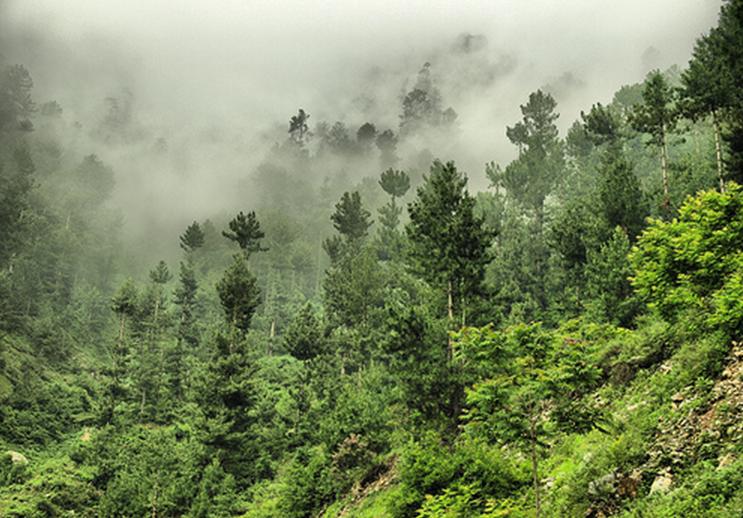
Murree is One of the most visiting hill station of Pakistan. For those who live downwards to it Murree is l ike a fantasy city. People from all over the country visit this beautiful hill resort to escape from the sweltering heat. Mountains covered with lush green trees, cold atmosphere, fresh air, beautiful valleys and most importantly clouds on the roads hugging you with full of happiness.
 ike a fantasy city. People from all over the country visit this beautiful hill resort to escape from the sweltering heat. Mountains covered with lush green trees, cold atmosphere, fresh air, beautiful valleys and most importantly clouds on the roads hugging you with full of happiness.
Murree town itself, built by the British colonial government soon after it captured this part of then India in 1850. Until 1876, Murree was the summer headquarters of the Punjab local government; after 1876 the headquarters were moved to Simla.

The name Murree is derived from 'marhi', "high place" although there is a popular belief it is named after the virgin Mary. Murree is one of the largest resort towns in the Galyat area of Pakistan, and is the capital city of Murree Tehsil (which is an administrative division of the Rawalpindi District). Murree is accessible by road from the centre of the Islamabad and Rawalpindi areas.
Murree lies between Kashmir Point and Pindi Point. As the names sugge st Kashmir point gives a panoramic view of snow laden Himalaya and Pir Panjal ranges in Kashmir while the Pindi point overlooks national capital Islamabad and sister city Rawalpindi. At Pindi Point one can enjoy ride on a Chairlift to three kilometers down to Bansragalli and enjoy a panoramic view of Hazara mountains as well as Rawalpindi Islamabad. The city of Murree lies in seven kilometer area between these two points. The most popular area in the hill station is the Mall road spanning over about two kilometer in beautiful settings.
 st Kashmir point gives a panoramic view of snow laden Himalaya and Pir Panjal ranges in Kashmir while the Pindi point overlooks national capital Islamabad and sister city Rawalpindi. At Pindi Point one can enjoy ride on a Chairlift to three kilometers down to Bansragalli and enjoy a panoramic view of Hazara mountains as well as Rawalpindi Islamabad. The city of Murree lies in seven kilometer area between these two points. The most popular area in the hill station is the Mall road spanning over about two kilometer in beautiful settings.
Development:
In recent years Bhurban and New Murree (Patriata), have also developed as a tourist centre. The whole Murree Galliat region is known throughout South Asia for its scenic beauty and fascinating greenery. Mountains overhung with pines and oaks, bubbling with gurgling springs, crisscrossed by rivulets, dotted with sprawling lawns and orchards overloaded with fruits present spectacle of Paradise on earth.
Health and medication:
There are many well equipped medical centres in Murree and surrounding which can always provide you with basic medical treatement,like Abbasi hospital at Suny Bank, Tariq medical centre Bhurban, Al-shifa clinic Murree and many more. Along with these medical centres there is a military hospital "CMH" situated on Murree mallroad. So you do not need to worry for medical treatement in case of any emergency while visiting Murree and surroundings.
Climate:
Weather plays an important part in life and economy of Murree. Murree remains charming all year round. It has four distinguishable seasons.
S pring:
 pring:
Spring in Murree starts in March and ends in middle of May. Maximum temperature during this period hovers between twelve to twenty and minimum between four and ten. The area receives heavy rain and hail storms during this season. The fruit trees laden with flowers give a spectacular view.
Summer:
Summer spans from may to end of August. June and July is the peak tourist sea son in Murree. In summer it is cool even chilly in the evening while light rain is common. In this season Everything and Anything can happen in Murree. This is the best season in the area and it receives most number of visitors during this season.
 son in Murree. In summer it is cool even chilly in the evening while light rain is common. In this season Everything and Anything can happen in Murree. This is the best season in the area and it receives most number of visitors during this season.
To some Murree may be a tacky and over-crowded hill-station in Pakistan but for many Murree is a heaven in summer. Some people may have experienced 45-50 degrees Celsius so therefore Murree’s cooler high altitude climate provides much needed relief from the sweltering heat.
Autumn:
With the advent of September autumn creeps in and last till the starts of winter in early December. This is the seasons of clear sky in the region when one can enjoy full view of mountains around without cloud hindrance. Temperatures are mild.
 Winter:
Winter starts in December and normally brings heavy snowfall. Murree and its surrounding areas are covered with thick layer of snow during most part of the season. Temperature mostly hovers around the freezing point.
Animals:
Many rare animals can be found in Murree. One example is the leopard, which inhabits the neighboring Galiyat region. More common animals include the Rhesus Monkey, foxes and various species of pheasant including the chir and kalij.
Places to See:
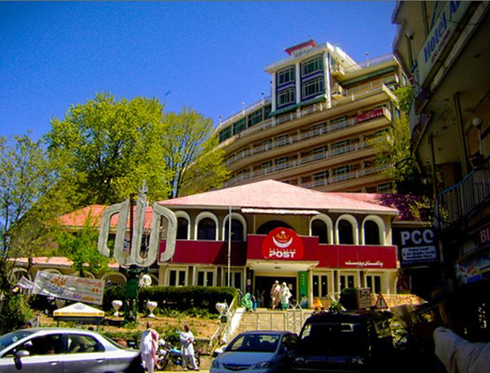
The Mall Road:
Mall road is the famous market place in Murree. A road full of life, hotels, r estaurants, handicraft shops and happy faces. People who visit Murree, get their rooms on Mall road. This is the place where people just walk till 2am or 3am in morning and enjoy the beautiful weather.
 estaurants, handicraft shops and happy faces. People who visit Murree, get their rooms on Mall road. This is the place where people just walk till 2am or 3am in morning and enjoy the beautiful weather.
It has bazaar downstairs, like 10 feet below the main Mall road. This is a place of shopping for visitors. Mall road is used to walk around and to have food.
It can be best visited after the sunset. if you want to save time visit hills at day time and Mall Road at night when you have to just shop or dine. It is a slope starting from General Post Office. Food & misc. sovenier shops are situated on the both sides of Road. It is open till midnight. You can buy everything at Mall and dine a variety of Pakistani dishes.
Pindi Point:
Pindi point is one of the prime points to visit in Murree. It is 15 minutes walk from mall road. It has a beau tiful view of vallies and mountains. You can see Pindi city from there. Chairlift rides go down 1.5 km from Pindi Point to Bansara Gali are really enjoyable. Scenary from chair lift is magnificent. Zigzag road passes below. Great pine trees stand throughout the journey. When go down the valley there is a stop point. You can enjoy a lot there. There is a coffee shop & children play land. Hills of Patriata can be seen there. A great jungle starts there. You can enjoy tracking. Chair lift is open from 9am till 6 pm.
 tiful view of vallies and mountains. You can see Pindi city from there. Chairlift rides go down 1.5 km from Pindi Point to Bansara Gali are really enjoyable. Scenary from chair lift is magnificent. Zigzag road passes below. Great pine trees stand throughout the journey. When go down the valley there is a stop point. You can enjoy a lot there. There is a coffee shop & children play land. Hills of Patriata can be seen there. A great jungle starts there. You can enjoy tracking. Chair lift is open from 9am till 6 pm.
Kashmir Point:
eave Mall road from other end, going up GPO and walk for fifteen minutes, about 1 km it will leads to Kashmir point. You may hike up the Kashmir point. The way passing by the Cadet College Murree goes towards the Murree Residence of the President of Pakis tan.
tan.
 tan.
tan.It has a beautiful sight seeing. You can see Kashmir mountains from this point. It is the highest spot in Murree and due to increasing rush on Mall road, this point is taking visitor’s attention day by day.
Now it has a long bazaar, a joy land and lots of eating places. Most of the visitors came to ease down and relax in Murree and need a quite place to live so they prefer to book a room in Kashmir point instead of Mall road.
Patriata(New Murree):
New Murree is about 15 kilometer away from main Murree hills on the Lower Topa side. It is a well developed hill station with great high rised trees, beautiful hills.
 developed hill station with great high rised trees, beautiful hills.
This is famous due to chair lift, which worth a ride. A world class chair lift & cable car system takes you from New Murree to Patriata. Total ride is about 7 km long. New Murree is on ground level between the hills. Here you have to buy the ticket for Chair Lift + Cable Car which is Rs. 200/- then a chair lift ride takes you to a middle hill. You can watch Kashmir mountains from middle Hill where Chair Lift takes you. You may stay here for some time & enjoy Tea/Coffee or just walk around. From there Cable car takes you to Patriata Hill. where you have much stuff to do. Walk freely everywhere. Just walk in the direction where most of the tourists are going. Straight road takes you to the highest point of the hill. Where scenary is panoramic. On one side you can watch Murree Hills & on the other side snow covered Kashmir Hills.
The Chair Lift & Cable Car journey is memorable of life time. You can witness lots of great scenaries of near & far hills. In winter all hills are covered with snow while in summer lush green scenaris could be seen.
You may ride a horse but ASK/FIX CHARGES before leaving otherwise  they will charge you too much. Similary don't hire a guide within patriata. People will come around you like they are helping you in taking pictures but then they ask huge amount for those services.
 they will charge you too much. Similary don't hire a guide within patriata. People will come around you like they are helping you in taking pictures but then they ask huge amount for those services.
Private car from Murree charges about Rs. 800/- for return journey. Driver will leave you at the gate of TDCP PATRIATA RESORT at New Murree & then take you back to Murree when you've finished.
You can’t stay there for long. Last cable car is at 5 pm which take every visitor back. At that time a person goes all the way whistling to check if there is any one left and then take last cable car.
River N eelam:
 eelam:
It is a nice place to have a picnic. People use to have snack and lunch at the corner of this river or sometimes in it. One can feel the cold wind and cool water which tends to be the best thing in summer. Enjoy the journey to this river Neelam, Mountains covered with lush green trees and high slopes of mountains creates an eye catching view. One don’t get to know the time if enjoying this cool wind and water there.
 Bhurban, boosting with five star Pearl Continental Hotel owned by Pakistan's best hotel chain and a nine hole Golf course has cropped recently as another tourist attraction in Murree area. Lying at an altitude of 6000 ft, Bhurban is situated at a distance of 13 kilometers from Murree on one of main roads leading to Azad Kashmir.
People use to visit Pearl Continental Hotel Bhurban which is on beautiful location. It has rooms starting from Rs. 10,ooo/- per day which changes according to season. It has an entry fee of Rs. 300/- which you can spend in the hotel in any activity. There is a Helicopter Pad which has a beautiful valley view.
Kulda na:
na:
 na:
na:Kuldana is the name of an extremely beautiful hill, which spreads over a lush green area of about five square kilometers. The area is densely populated by a large variety of trees and plants and inhabited by various kinds of wild life species specially birds, butterflies and monkeys. At times snow leopards, cheetahs and jackals can also be seen crossing roads and tracks.
Upper Topa and Lower Topa:
Upper Topa and Lower Topa comprise the Murree Hills in Murree. Establi shed by the British during their rule of the subcontinent, it is located at an altitude of 7000 ft and provides a pleasant getaway for tourists in the scorching summer. The winter season often covers Upper Topa with a blanket of snow. Upper Topa and Lower Topa comprise the Murree Hills in Murree. Established by the British during their rule of the subcontinent, it is located at an altitude of 7000 ft and provides a pleasant getaway for tourists in the scorching summer. The winter season often covers Upper Topa with a blanket of snow.
 shed by the British during their rule of the subcontinent, it is located at an altitude of 7000 ft and provides a pleasant getaway for tourists in the scorching summer. The winter season often covers Upper Topa with a blanket of snow. Upper Topa and Lower Topa comprise the Murree Hills in Murree. Established by the British during their rule of the subcontinent, it is located at an altitude of 7000 ft and provides a pleasant getaway for tourists in the scorching summer. The winter season often covers Upper Topa with a blanket of snow.
Galiyat:
The Galiyat are popular due to the cool weather and beautiful scenery. They are also very closely located to areas with high population.
The mountains are covered by thick pine forests which give the Galiyat a unique character. It is one of the greenest areas of Pakistan and receives better rainfall than most areas. The resorts were developed by the British and you will see a lot of colonial influence there.
The natural beauty of the area lies in the pine forests which are a haven for wildlife and insects. Rhesus Monkeys wait to be fed by curious tourists who may have arrived from busy urban areas and have never seen wildlife so close and taking food from them. Other wild animals which occur here are Leopards, Red Fox, Porcupine, Wild Cats, Black Bear, Pheasants and a large diversity of small birds including Tits, Woodpeckers, Tree-creepers, Warblers and Parakeets. There are plenty of walking trails in the Galiyat and some lead to the highest peaks of Miranjani and Mukshpuri, both which can be done in a day.

Darya Gali :
Darya Gali is a village and union council of Murree Tehsil in the Rawalpindi District of Punjab. It is located in the north of the Murree and is bounded to the north by the North-West Frontier Province, to the south by Ghora Gali and Murree-and to the west by Rawat.
Rawat:
Rawat is a village and union council of Murree Tehsil in the Rawalpindi District of Punjab. It is located near to the border with North-West Frontier Province and Kashmir. The tourist resort of Bhurban is located here.

It is a very developed union council of Murree in terms of availability of facilities and basic needs which are essential to live and service in an effective manner. The basic facilities which are available here consists of many hotels, schools and colleges, medical centres, and well equipped markets. The famous Pearl Continental hotel lies in this union council. There are many well reputed schools and colleges in this union council and students from all other union council are studying in these schools and colleges to complete their education.
Rawat is very well known for having the facility of basic medical treatment in case of emergency as it has many medical clinics here which are attended by many professional doctors.
There are many famous villages for which Rawat is the commercial centre. Some of them are; Morha darogha, moori khambaal, sood gangaal, dhok amban and others. Morha darogha is famous in the whole region for its reputation and people. It is quite convenient to get to Morha darogha from Rawat.
Ghora Galli:
The vi sitors pass Samli sanatorium and the Ghora Gali (elevation 5,000 ft ),known as such because this place was used for the changing of horses used for carriages operating between Rawalpindi-Murree and further on to Srinagar (Kashmir)during the British period. TDCP construct a restaurant in-between the natural sceneries for tourist. The snake bar and all other facilities are available here.
 sitors pass Samli sanatorium and the Ghora Gali (elevation 5,000 ft ),known as such because this place was used for the changing of horses used for carriages operating between Rawalpindi-Murree and further on to Srinagar (Kashmir)during the British period. TDCP construct a restaurant in-between the natural sceneries for tourist. The snake bar and all other facilities are available here.
Nathiagali:
The most centrally placed and the most well known of the Galis is Nathiagali. Nathiagali is situated at equidistance of 35 kilometers from Murree as well as Abbottabad at an attitude of 8400 feet. It provides splendid scenic views and commands a fine view of the snow-capped peaks of Kashmir and Kohistan on one side and the Pothwar Plain on the other. In the foreground, to the north-east rise the green slopes of Miran  Jani Mountain. Nathiagali provides unspoiled natural beauty and breathtaking view of mountains. It is located at the doorsteps of 9779 feet Miranjani and 9258 feet Muskhpuri mountain. On a clear day, may be seen the towering heights of the Nanga Parbat, with all its snow-crowed majesty.
 Jani Mountain. Nathiagali provides unspoiled natural beauty and breathtaking view of mountains. It is located at the doorsteps of 9779 feet Miranjani and 9258 feet Muskhpuri mountain. On a clear day, may be seen the towering heights of the Nanga Parbat, with all its snow-crowed majesty.
Hosting Governor House, Government (Chief Minister) House and offices of other departments of Government of North West Frontier Province, Nathiagali virtually serves as summer capital of the province. It is connected with Abbottabad on one hand and Murree and on wards to Islamabad onto the other with well constructed and beautifully laid highways. There is quite large number of hotels and restaurants of various categories in the town along with rest houses of different departments. Other facilities like Banks, internet cafe, hospital, fuel station and workshops are available.

A little up from Nathia Gali bazar, at the top of the hill is situated "Green Spot". Actually this is a Pakistan Air Force reserved area, but it is open for tourists and families. You can enter Green Spot by paying Rs. 5/- as entrance fee. View of Nathiagali and neighbouring area is magnificent from here.
Baraga li:
li:
 li:
li:From Nathiagali to Abbottabad the road runs down from about 9000 ft. to 4500 ft. About three miles down there lies Baragali a small hill station, located at an altitude of 7,900 ft/2408 kms. The last of the chain of the Galis it is only 15 miles/24 kms. from Abbottabad on the road to Nathiagali.
Ayubia:
Ayubia has become the most important spot in the Galliat after Nathiagali. In 1984 an area of 1,684 hectares of mountain forest was declared as a national park, with the aim of preserving the beautiful forest and biodiversity. The park area was expanded through a northern extension in 1998 to 3,312 hectares. The elevation of "Ayubia National Park" ranges between 1,050 meters in the valleys to 3,027meters at the mountain tops within. These mountains are 40 million to 170 million years old.
Ayubia is a complex of four small hill stations. i) Ghora Daka. ii)Khanspur. iii)Changla Gali and iv)Khairagali. These four resorts scattered over an area of about 16miles/26 kms. It is named after late Field Marshal Mohammad Ayub Khan, President of Pakistan at that time.
i) Ghora Daka:
The chairlifts provided at Ghora Daka is a matter of great attraction. They take you above to the peak of forsted hills. There are Green, wooded mountains and steep precip ices on one side and tall, majestic pines on the other. Wild life, including bear, cheetah, monkeys and a great variety of birds is known to be found in the thickly afforested slopes. Top point is called "Neelam View" because River Neelam of Kashmir can be viewed from here.
 ices on one side and tall, majestic pines on the other. Wild life, including bear, cheetah, monkeys and a great variety of birds is known to be found in the thickly afforested slopes. Top point is called "Neelam View" because River Neelam of Kashmir can be viewed from here.
There is a spot on Murree-Nathiagali Road, near Ayubia Chair Lifts, called "Bander Point". In this area great number of monkeys live in the jungle. They are so friendly that they come on the road and take food items directly from a person's hand. They do not harm by any means.
ii)Khanus Pur:
Three kilometer down the road from Ayubia is old summer resort of Khanspur. Khanspur is a part of the Ayubia National Park and Reserve Forest. The area is a good example of moist (le sser) Himalayan temperate forest in Pakistan. Terraced agricultural fields are located mostly on valley bottoms. The holdings are very small. Grassland and forest occur on steeper slopes and are proportionally more widespread. Most if not all of the vegetation in and around the Ayubia National Park and Reserve Forest is heavily influenced by the human activities. Apart from collection by locals, firewood from the park is also gathered for use by the hotels and summerhouses. Situated between Murree and Nathia Gali, Khanspur is relatively quiet where one can find privacy as well as unmarred vistas of the green hills together.
 sser) Himalayan temperate forest in Pakistan. Terraced agricultural fields are located mostly on valley bottoms. The holdings are very small. Grassland and forest occur on steeper slopes and are proportionally more widespread. Most if not all of the vegetation in and around the Ayubia National Park and Reserve Forest is heavily influenced by the human activities. Apart from collection by locals, firewood from the park is also gathered for use by the hotels and summerhouses. Situated between Murree and Nathia Gali, Khanspur is relatively quiet where one can find privacy as well as unmarred vistas of the green hills together.
iii)Khairagali:
The road from Murree to Nathiagali is like travel into paradise.  Going through top of one of the most beautiful mountains in the world. There are lush green alpine forest all along the road. Throughout the journey one enjoys panoramic view of snow clad Pir Panjal and other ranges in Kashmir . There are a number of small dwellings all along, where one can stay and rest. First among them is Khairagali. It is situated at a distance of 16 kilometers from Murree at an elevation of 2346 meters. It commands a panoramic view on either side of the ridge.
 Going through top of one of the most beautiful mountains in the world. There are lush green alpine forest all along the road. Throughout the journey one enjoys panoramic view of snow clad Pir Panjal and other ranges in Kashmir . There are a number of small dwellings all along, where one can stay and rest. First among them is Khairagali. It is situated at a distance of 16 kilometers from Murree at an elevation of 2346 meters. It commands a panoramic view on either side of the ridge.
iv)Changlagali:
Changla Gali is a hill station located in the Galiyat, are which borders NWFP and Punjab, starting at Murree and ending at Thandiani .About two miles further up and nine miles/14 kms. from M urree, on the main Abbottabad-Murree road, is Changla Gali, splendidly situated at an altitude of 8,400 f / 2560m amidst thick pine forest. The 9,000 f / 2743 m. Changle peak commands, on the one side a fine view of the Jhelum Valley, on the other side it presents a strikingly panoramic of the Murree hills, the southern portion of the Hazara district and the distant plains of Rawalpindi.
 urree, on the main Abbottabad-Murree road, is Changla Gali, splendidly situated at an altitude of 8,400 f / 2560m amidst thick pine forest. The 9,000 f / 2743 m. Changle peak commands, on the one side a fine view of the Jhelum Valley, on the other side it presents a strikingly panoramic of the Murree hills, the southern portion of the Hazara district and the distant plains of Rawalpindi.
Changlagali is the highest point in the Murree Galliat area which is accessible by road. There is a rest house located in the most picturesque surroundings. A number of good hotels and restaurants are available at the spot. Changla Gali is one of the smaller resorts, most people preferring to stay at either Nathiagali or Murree.
Natural springs abound Changlagali on the slopes and their water is stored in reservoirs to provide water supply for Murree and adjoining areas.
Mushkpuri Top: 

Mushkpuri Hill, the second highest hill in Galiyat, above 9,000 feet sea level. This may be one of the closest places where you can gain such height. Starting from Pines Hotel NathiaGali or Dewan House DungaGali, the trek passes upward through lush green forests. Beautiful Daisies dance and swing to greet the hiker and sets the romantic charm, specially in the rainy weather with hide and seek of the scenery is all around you.
Dungagali:
From Ayubia visitors returns to Murree-Nathiagali Road and climb further for about three mile s and then jumps in view Dunga Gali. Dungagali is a picturesque small resort situated on the slopes of the Mushkpuri hill (2376 m.). It commands a charming view of a series of wooded spurs projecting towards the river Jhelum on the western side. From Dungagali one can climb the 2813 meter peak of Mushkpuri, which is the highest point in the range. Natural springs abound on the slopes. It is 30 km from Murree.
 s and then jumps in view Dunga Gali. Dungagali is a picturesque small resort situated on the slopes of the Mushkpuri hill (2376 m.). It commands a charming view of a series of wooded spurs projecting towards the river Jhelum on the western side. From Dungagali one can climb the 2813 meter peak of Mushkpuri, which is the highest point in the range. Natural springs abound on the slopes. It is 30 km from Murree.
At Dunga Gali a huge circular and open to the sky water tank of strong steel sheets was built, having a diameter of about 30 meters and a height of about 10 meters. Today it lies completely within the Ayubia National Park. In the mountainous heights behind Dunga Gali, run-offs from natural springs and rain-water channels were engineered and networked to flow into this steel water storage tank. A track abou t 3 meters wide on the average was carved out along a mountain slope, through thick forest, and a water pipeline was laid in the centre of the track, to carry the stored water to Ayubia, from where it was supplied to Murree at an elevation nearly a thousand meters below the starting point in Dunga Gali. The pipeline was covered over with earth and stones and the track now hiding the water pipeline came to be called the Pipeline Walk, at 2,499 meters above sea level, meandering along a mountain side, through still fairly thick coniferous forest, the Pipeline Walk is a ‘must experience’ for every visitor to the area who loves and respects nature and can walk for 4 kilometers without raising his or her voice. In fact there is really no need for any conversation on this trail, even if you are not alone. For it is divinely important to turn your ears to the sound of nature around as your eyes feast on a verdant valley on one side, and your nose picks up the heady mix of aromas of rain-soaked earth, dew-dampened undergrowth, pine cones and a green forest washed by heavy thunder-showers overnight.
 t 3 meters wide on the average was carved out along a mountain slope, through thick forest, and a water pipeline was laid in the centre of the track, to carry the stored water to Ayubia, from where it was supplied to Murree at an elevation nearly a thousand meters below the starting point in Dunga Gali. The pipeline was covered over with earth and stones and the track now hiding the water pipeline came to be called the Pipeline Walk, at 2,499 meters above sea level, meandering along a mountain side, through still fairly thick coniferous forest, the Pipeline Walk is a ‘must experience’ for every visitor to the area who loves and respects nature and can walk for 4 kilometers without raising his or her voice. In fact there is really no need for any conversation on this trail, even if you are not alone. For it is divinely important to turn your ears to the sound of nature around as your eyes feast on a verdant valley on one side, and your nose picks up the heady mix of aromas of rain-soaked earth, dew-dampened undergrowth, pine cones and a green forest washed by heavy thunder-showers overnight.
It commands a charming view of a series of wooded spurs projecting towards the River Jhelum on the west. From Dunga Gali one can climb the 9,232 ft/2814 mtr peak of Mushkpuri which is the highest point in the range.
Khairagali, Changlagali and Dungagali are situated on a newly rebuilt beautiful Murree Nathiagali road. A few kilometers from Changlagali one reaches Kuzagali. From Kuzagali one can go either to Ayubia to the right or Nathiagali to the left.
Trekking In Galliat:
Galliat region provides excellent opportunities for tracking. Different tracks passing through lush green virgin forests are available for the tourists. NWFP Forest Department is doing a good work to keep these tracks in good condition. These tracks include:
Four kilometer track originating near Shangrila Hotel in Nathiagali passe s through thick pines forests and goes to 9243 feet Mushkpuri top. on the way one can have splendid view of Lalazar Park. Lalazar Park is situated at one kilometer up the track from Nathiagali. Hikers on their way to Mushkpuri top are presented with colourful fairy fragmented carpet of flowers in the green Meadwos of Mushkpuri especially at the end of the rainy season.
 s through thick pines forests and goes to 9243 feet Mushkpuri top. on the way one can have splendid view of Lalazar Park. Lalazar Park is situated at one kilometer up the track from Nathiagali. Hikers on their way to Mushkpuri top are presented with colourful fairy fragmented carpet of flowers in the green Meadwos of Mushkpuri especially at the end of the rainy season.
Dungagali to Mushkpuri:
This second track available to go to Mushkpuri. It starts from Dungagali, a place four kilometer short of Nathiagali, on Murree-Nathiagali Highway. It equal in length to Nathiagali-Mushkpuri track. On the way one has the option to go to Lalazar Park, which of course increases the distance to the Mushkpuri top.
Dungagali to Ayubia:
 Again a 4 kilometer long track which is laid on the pipeline supplying water from Dungagali to Murree. In contrast to Dungagali/Nathiagali to Mushkpuri tracks, it is plain track and does not have ay ups and downs but like the earlier mentioned tracks it passes through lush green pine forests.
From Ayubia one can follow the track for another four kilometer length to Changlagali and from there for approximately another length of same distance to Khiaragali.
Nathiagali to Miranjani:
Eight kilometer track starts near Governor House in Nathiagali and 9779 feet Miranjani top. Fro m Miranjani one can follow the tack for a further distance of 10 kilometers to Dagri. on the way one passes through Chaniangali and Lamba Dhaka (long mountain) situated at an altitude of 9541 feet and 9545 feet respectively. Another patch of thirteen kilometer track takes one to Birangali.
 m Miranjani one can follow the tack for a further distance of 10 kilometers to Dagri. on the way one passes through Chaniangali and Lamba Dhaka (long mountain) situated at an altitude of 9541 feet and 9545 feet respectively. Another patch of thirteen kilometer track takes one to Birangali.
From Birangali one can either take a 13 kilometer track down to Azizabad on Nathiagali-Abbottabad road or take another clime to 8831 feet Thandiani top.
Nightlife in Murree:
One could find an attractive thing to take a view from kashmir point at night, because lighting on nearby mountains and valleys look like stars on earth and gives a beautiful view from height,must see this also you will find people walking all night on mall road from gpo to pindi point and shops opened till late night,
Where to Stay:
Murree being a well established tourist destination has a wide variety of lodgings available to suit all pockets. There are various standard hotels are available in Murree. Another option is to hire summer houses. Murree also has a number of private an d government owned rest houses or Dak bunglows. Generally the summer season rates are 5 to 6 times the winter off season rate.
 d government owned rest houses or Dak bunglows. Generally the summer season rates are 5 to 6 times the winter off season rate.
Where to Eat:
There are many restaurants in Murree, mostly along The Mall.
Where to Buy:
Murree has a variety of handicraft shops selling curios for the tourist to remind them of their visit to this hill station. Traditional clothing items , head wear, carved walking sticks, jewelery items and leather goods are abundantly available.
How to reach:
Reason of being most visiting hill station is its approach. It is almost two hours drive from our capital city Islamabad. Roads are broad and safe.
 of being most visiting hill station is its approach. It is almost two hours drive from our capital city Islamabad. Roads are broad and safe.
Murree is situated at a distance of only thirty kilometers from Pakistani capital Islamabad. A well constructed all weather road network connects Murree with Islamabad, and areas in Punjab, North West Frontier Province and Azad Kashmir.
Islamabad Murree section of Islamabad-Muzaffarabad Expressway (N-75) was opened to traffic in 2008. A special link road has been constructed to link the city with the Expressway. Traffic will further ease up when the Expressway will be connected with the Rawalpindi-Srinagar Highway at Lower Topa some time this summer. Expressway has considerably reduced travel time between Islamabad/Rawalpindi and Murree and provided an hassle free link to New Murree as well Azad Kashmir. The road runs through virgin forests and is more safe and smooth to drive on as compared to historical Rawalpindi-Srinagar Highway which used to be the only link between Murree and Islamabad and still provides important link to Murree.
 the Expressway. Traffic will further ease up when the Expressway will be connected with the Rawalpindi-Srinagar Highway at Lower Topa some time this summer. Expressway has considerably reduced travel time between Islamabad/Rawalpindi and Murree and provided an hassle free link to New Murree as well Azad Kashmir. The road runs through virgin forests and is more safe and smooth to drive on as compared to historical Rawalpindi-Srinagar Highway which used to be the only link between Murree and Islamabad and still provides important link to Murree.
Taxis and buses run from Islamabad, and take about 1 hour. It is a picturesque drive and has a few well developed tourist spots at Charra Pani and Company Bagh. The Chattar water park is only 15 minutes outside Islamabad. There is also an alternate but longer route to Murree from Islamabad via Nilore and Simli Dam. The alternate route joins at Lower Topa. The mountain drive is refreshing and the scenery is breath-taking especially on the Nilore-Simli-Lower Topa route.
Another two way road is constructed from toll-plaza to Pataryata, the drive is very scenic and refreshing. An link road is available for those want to go to Murree.
Beware of the talkative Taxi drivers at the Islamabad Airport. Whenever you are hiring a Taxi to Murree fix the rates with them at the airport and don’t give them a penny more. Maximum charges for a taxi to Murree are Rs. 1000. These Taxi drivers though puzzle the tourists in the middle of the journey by asking them which route shall they take to Murree. They will say the motorway is a swift way to reach to murree in a time period of just one hour and they will charge rupees four hunderd more. They also get commission form the local hotels at Murree to bring the tourists and they posing as very helpful being will try to get you a nominal room at high charges. Make sure before coming to Murree that at which hotel you want to stay. A list of telephone numbers of almost every hotel in Murree is available on net. Contact the hotel yourself first and come straight to the place you want to stay.
Sight Seeing from Pindi to Murree:
Chattar:
The Chattar water park is only 15 minutes outside Islamabad. There is also an alternate but lo nger route to Murree from Islamabad via Nilore and Simli Dam. The alternate route joins at Lower Topa. The mountain drive is refreshing and the scenery is breath-taking especially on the Nilore-Simli-Lower Topa route.
 nger route to Murree from Islamabad via Nilore and Simli Dam. The alternate route joins at Lower Topa. The mountain drive is refreshing and the scenery is breath-taking especially on the Nilore-Simli-Lower Topa route.
This resort nestles at the base of Murree hills at a distance of 15 km on Islamabad-Murree road. This place offers scenic walks, gently flowing stream, waterfall and the surrounding hillside are a perfect attraction. The resort has a restaurant, barbecue and two air-conditioned tourist cottages. The Children's Park and playground are spread over an area of 12.5 ac res.
res.
 res.
res.Salgiraan:
It is 29km from Islamabad and 5 km from Chattar Bagh. TDCP develop this spot and make it attractive for picnic. Mostly people come to stay here for 15 to 20 minutes have a Cup of tea or cold drink take some rest and then start their journey towards Murree.
 Chara Pani:
Chara Pani is about 38km from Rawalpindi. Charra Pani where cold water springs gush out of the hillside. People stop here for a cup of tea or a cold drink. Colorful buses, wagons and Cars are parked here for a wash. The atmosphere of this spot is good for health that's why the major sanatorium of TB is established here. Delicious snake bar is available.
Simli Dam:
Simli dam is one of those gems, hidden deep among the mountains, that this region is so famous for. About 30 km from Islamabad lies Simli Lake and the Dam. It can be reached via Lehtrar road or via Bhara Kahu. It is fed by the melting snow and natural springs of Murree hills. Angling and boating is also allowed in the lake. For fishing, you need to have license (permission)from CDA (Capital Development Authority), Islamabad. Best view of simli lake is from Ban Karor Road near Bassi. Best time to see the beauti of Lake is from April to September.

There is only one guest house in Simly Dam operated by CDA (Capital Development Authority), Islamabad. Before you plan to stay here, you need to have permission to stay & visit this beautiful guest house from CDA Head Office located in Islamabad.
The Capital Development Authority (CDA) has planned to increase the storage capacity of the Simli Dam from 2,305 square feet to 2,317 square feet by onstructing “auxiliary spillways. The water stored in the lake is supplied to Islamabad for drinking purposes.